A restricted byway allows you the right to pass on foot, on horseback (or accompanied by a horse), and with vehicles that are not propelled mechanically – including horse-drawn vehicles, but also including bicycles. A footpath is a way that may be passed on foot, or using a mobility aid. Cycling on a footpath is forbidden
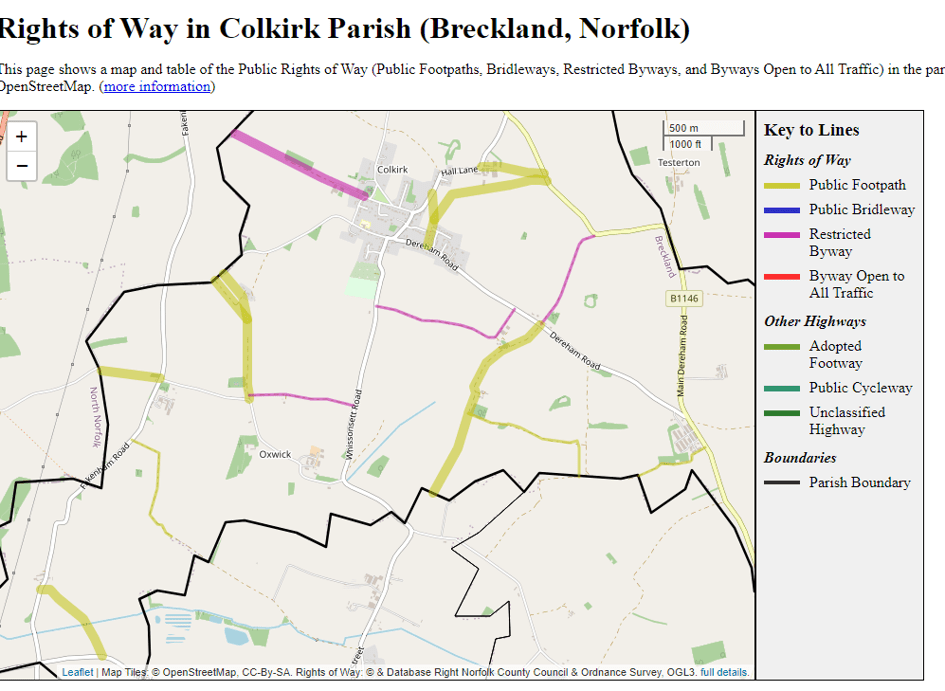
PARISH OF COLKIRK Footpaths
Restricted Byway No. 1 (St. Mary’s Church to Parish Boundary). Starts near St. Mary’s Church and runs north westwards passing the Rectory to the parish boundary where it joins
a path leading to Litcham Road in Toftrees.
Footpath No. 2 (Hall Lane to Footpath No. 3). Starts from Hall Lane and runs southwards to join Footpath No. 3.
Footpath No. 3 (Common End Road to Fakenham Road). Starts from Common End Road and runs north north-eastwards to join the southern end of Footpath No. 2, then bears north
eastwards and then east north eastwards, passing to the south of Hall Farm, to enter Fakenham Road.
Footpath No. 4 (Hall Lane to Fakenham Road). Starts from Hall Lane and runs eastwards through Hall Farm premises, then bears east south eastwards and then eastwards again to
enter Fakenham Road approximately 25 yards north of Footpath No. 3.
Restricted Byway No. 5 (Long’s Lane). Starts from Dereham Road at Common End and runs north eastwards to enter Fakenham Road.
Restricted Byway No. 6 (Colkirk-Whissonsett Road to Dereham Road). Starts from the Colkirk-Whissonsett Road and runs east south eastwards to Manor Farm, then turns north
eastwards to enter Dereham Road 200 yards north west of Common End.
Footpath No. 7 (Colkirk – Raynham Road to Oxwick Church). Starts from the Colkirk -Raynham Road at the parish boundary, and runs south eastwards to Manor Farm, Oxwick,
then continues southwards passing the south eastern end of Water Lane (Footpath No. 8) and Oxwick Church, to enter the public highway at its junction with Restricted Byway No. 10.
Footpath No. 8 (Water Lane). Starts from the Colkirk – Raynham Road at the parish boundary and runs south eastwards to join Footpath No. 7.
Footpath No. 9 (Toftrees Road to Raynham Road). Starts from Toftrees Road north of Hill House, Oxwick and runs in a west north westerly direction to enter Raynham Road at the parish boundary.
Restricted Byway No. 10 (Footpath No. 7 to Colkirk – Whissonsett Road). Starts from the public highway at its junction with Footpath No. 7 and runs in an easterly direction to enter the Colkirk – Whissonsett Road.
Footpath No. 11 (Dereham Road to Parish Boundary). Starts from Dereham Road at Common End opposite Long’s Lane (Restricted Byway No. 5) and runs in a south westerly
direction to join the north western end of Footpath No. 12 at Hazelbush Farm. From this point the path continues south south westwards to the parish boundary where it joins
Whissonsett Footpath No. 1.
Footpath No. 12 Starts at a point on Footpath No. 11 some distance south of Hazel Bush Farm and runs in a generally east south-easterly direction to the north-eastern corner of a
small wood. The path then runs southwards to the parish boundary where it meets Horningtoft Footpath No. 1.
Footpath No. 13 (Horningtoft Road to Parish Boundary). Starts from the Horningtoft Road and runs south westwards to the parish boundary where it joins Horningtoft Footpath No. 1.
Footpath No. 14 (Fakenham – Litcham Road to Whissonsett Footpath No. 2). Starts from a point on the Fakenham – Litcham Road south of Hill Farm (Oxwick) to run in a southeasterly direction along a track following field boundaries, and then in a southerly direction still following the track and field boundaries. Up to this point the path is at a width of 2
metres. It then turns and continues in a south-easterly direction to the parish boundary to meet up with Footpath No. 2 (Whissonsett). June 2000
Footpath No. 15 (Tittleshall Road to Whissonsett Road). Starts from Tittleshall Road south of Pattesley House and runs eastwards for approximately 60 yards, then runs south eastwards crossing river by means of footbridge to enter Whissonsett Road
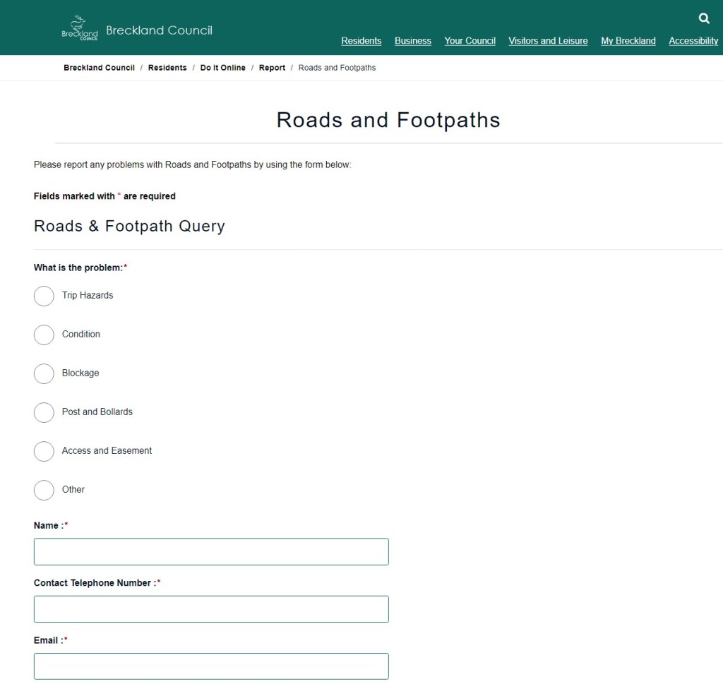
Lets Breckland know if there are any problems with the Foot paths
http://www.breckland.gov.uk/article/4531/Roads-and-Footpaths